Student-Faculty Projects and Research
Drainage basin evolution, meltwater routing, and fluvial system response to base level fluctuations since the last glacial maximum in the Great Lakes region and upper Mississippi basin, USA.
- Project 1: The Lake Superior basin: Natural geomorphic experiment, deepwater-terminating ice stream, and isostatically adjusting rift (National Science Foundation FRES program)
- In the summer of 2022, the EARTH Systems Laboratory received a $705,829 award from the National Science Foundation’s Frontier Research in Earth Sciences Program for proposed collaborative work on the Lake Superior basin totaling ~$2.8 million. This work is led by the MNiMORPH research group and, specifically, in collaboration with colleagues at the University of Minnesota (Andrew Wickert, Max Bezada, Keisha Varma, Karen Gran), University of Wisconsin-Superior (Andy Breckenridge), University of Wisconsin-Madison (Marianne Haseloff, Luke Zoet), and Harvard University (Jerry Mitrovica).
- For more information on this project
- Summary: The main objectives of faculty and students in the EARTH Systems Laboratory will be to investigate the relationship between the recent deglacial history and formation of rivers and their valleys on the North Shore of Lake Superior, as well as understanding two of the lake’s outlets. Larson will seek to date and interpret sediments and outcrops around Lake Superior and will work with students focusing on the chronology of and processes that resulted from the lake sending water into the St. Croix River valley and Lake Michigan. However, students and faculty in the EARTH Systems Laboratory will take part in all aspects of this NSF FRES-funded research.
- If you are interested in this work, please contact phillip.larson@mnsu.edu.
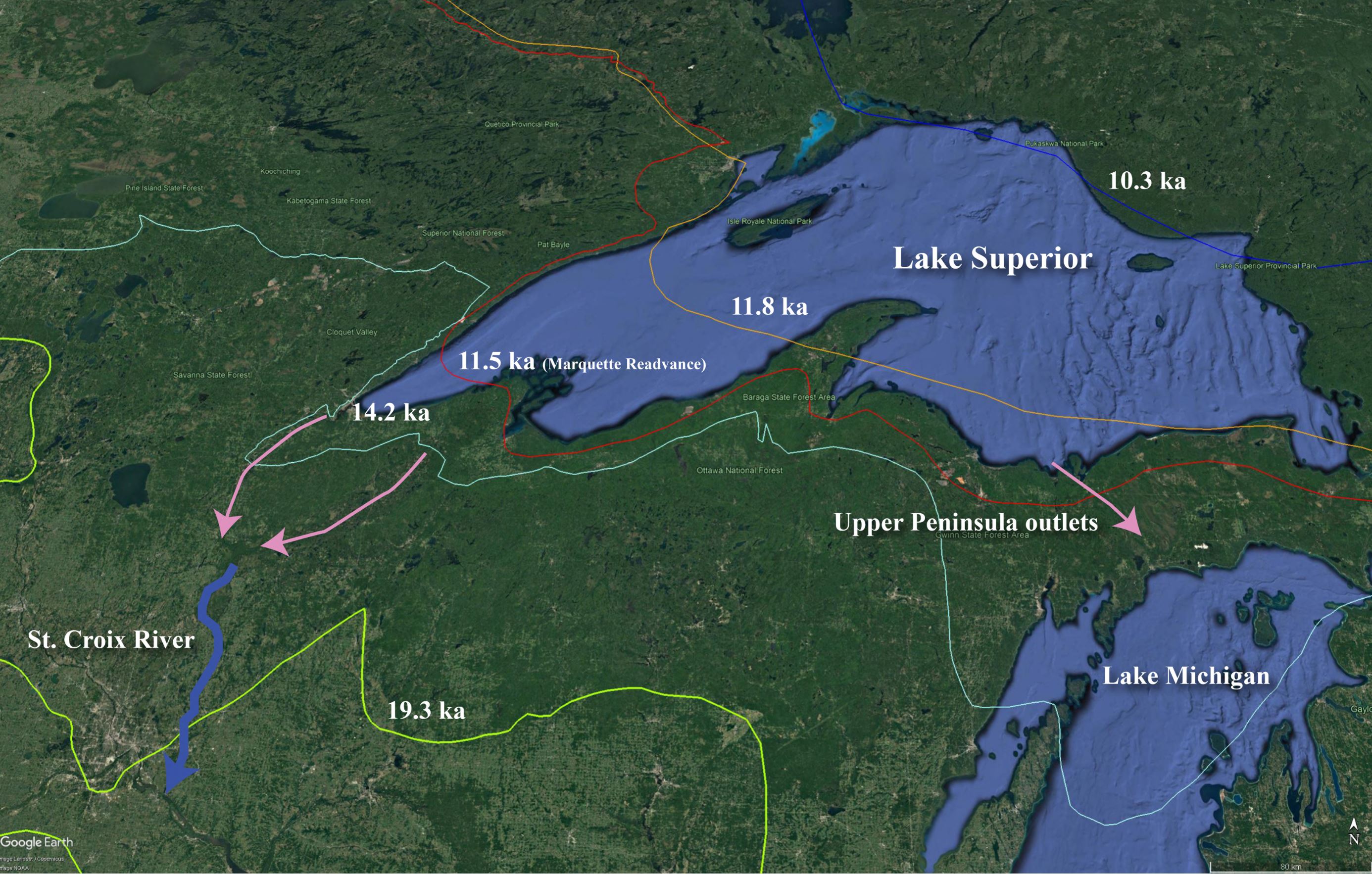
(Image Above: Lake Superior with outlets that will be studied (pink) and ice margins from last glacial maximum (green – 19.3 ka) through 10.3 ka. Map was created by the EARTH Systems Laboratory with ice margins depicted here from Dalton et al., 2020 in Quaternary Science Reviews).
- Project 2: Last glacial maximum to post-glacial drainage basin evolution of the Mississippi, Minnesota, St. Croix, Cannon, Whitewater, and Chippewa Rivers (Minnesota and Wisconsin) and their valleys.
- Significant meltwater discharge and sediment was routed through the upper Mississippi River and its tributaries at and post last glacial maximum. This meltwater routing was occasionally catastrophic in nature, as proglacial lakes (Lake Agassiz, Lake Duluth, Lake Minnesota, Lake Grantsburg, etc.) spilled out across the landscape and down rivers, carving deep valleys into till, outwash, and bedrock. Ultimately, these events resulted in fluctuations in base level for tributary systems draining into these meltwater corridors. For over 15 years, faculty in the EARTH Systems Laboratory, along with regional collaborators and the MNiMORPH group, have been attempting to reconstruct the timing of events that transformed these landscapes and the evolution of these landscapes in response to changing base level during deglaciation.
- Work is ongoing in the upper Mississippi, Minnesota, St. Croix, Cannon, Whitewater, and Chippewa Rivers in Wisconsin and Minnesota, USA.
- See Examples.
- Winner of the GK Gilbert Award from the AAG in 2019 (see: https://aag-gsg.org/awards/gk_gilbert_award/)
- If you are interested in this work, please contact phillip.larson@mnsu.edu
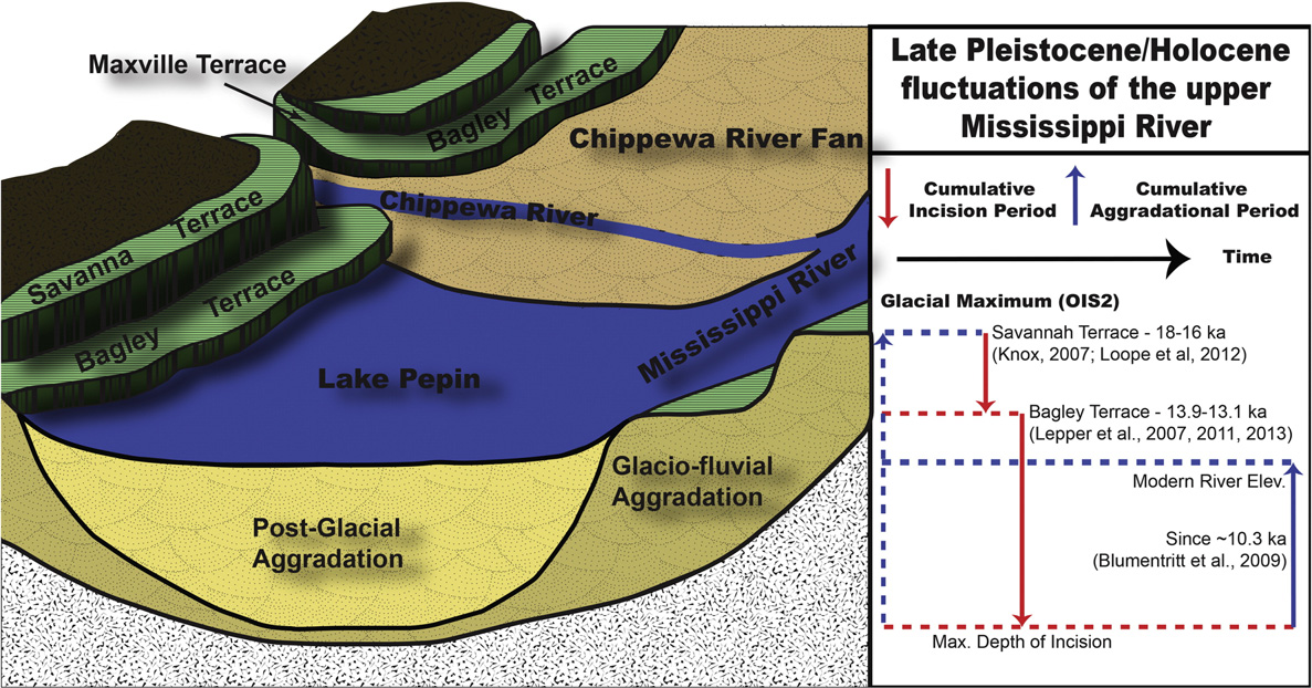
(Image Above: Simplified late Pleistocene/early Holocene history of base level fluctuations on the Mississippi River. Created for a publication by EARTH Systems Lab faculty and collaborators. Faulkner et al., 2016)
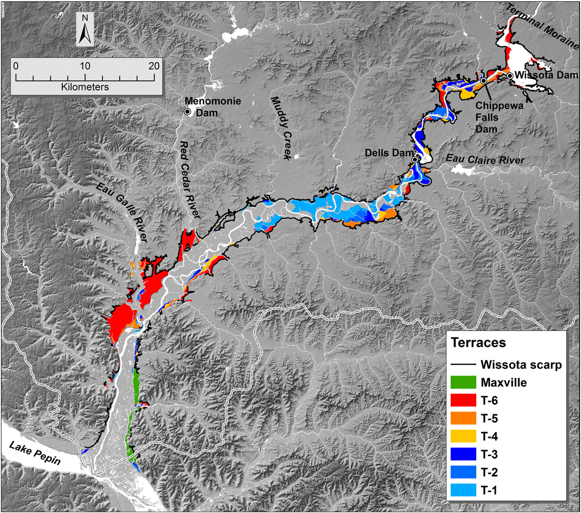
(Image Above: River terraces of the Chippewa River valley. Abrupt base level lowering, caused by meltwater driven incision of the Mississippi, resulted in incision and complex response of the Chippewa River leaving behind a suite of terraces as evidence of ongoing landscape evolution since the late Pleistocene. Created for a publication by EARTH Systems Lab faculty and collaborators. Faulkner et al., 2016)
Paleoenvironmental change at and post last glacial maximum via investigation of periglacial and aeolian deposition and landforms.
- Project 3: Aeolian deposits and landforms are abundant in the landscapes of the upper Mississippi River basin. They vary greatly in terms of form. To date, the following landforms have been identified: sand sheets, sand stringers, sand ramps, climbing dunes, parabolic dunes in isolation or in fields, and cliff-top dunes. Development of these aeolian deposits and landforms are poorly understood in this region and early research is beginning to point to large, regional-scale sandy aeolian activity in the late Pleistocene and early Holocene (possibly centered around the Younger Dryas and up to 9-10 ka). It is hypothesized that mid-Holocene and late Holocene aridity may also influence relatively minor, but later, periods of deposition. Of course, loess deposition was occurring beyond the ice margin during the last glacial maximum and for thousands of years beyond. This has been well documented by prior researchers (for example, see work of EARTH Systems Lab collaborator Randy Schaetzl – Michigan State University). Therefore, the EARTH Systems Laboratory is studying poorly understood sandy deposits and landforms to add to our understand of loess deposition and processes to help understand the deglacial paleoenvironment and the evolution of geomorphic processes that occurred as deglaciation progressed. This is closely coupled with work investigating periglacial deposits and forms like sand/ice wedges preserved in the landscape.
- If you are interested in this work, please contact phillip.larson@mnsu.edu
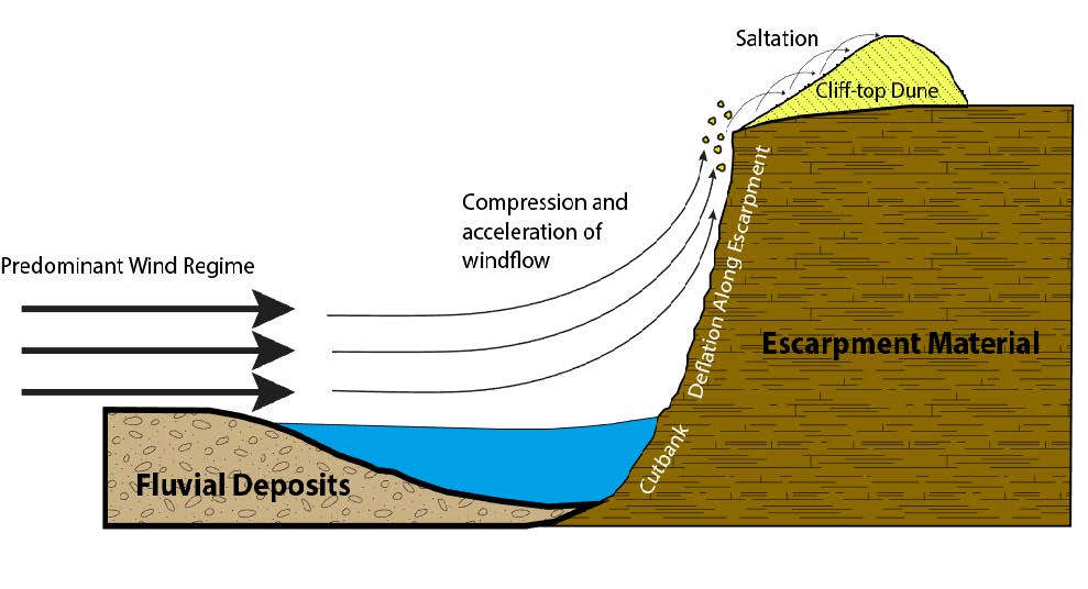
(Image Above: A cliff-top dune depositional model proposed to explain the origin of cliff-top dunes in actively incising fluvial systems. Cliff-top deposition appears to be tied to both the river incising into its landscape and also correlates to potentially more arid periods of the Holocene. Created for a publication by EARTH Systems Lab faculty and collaborators. Larson et al., 2008).
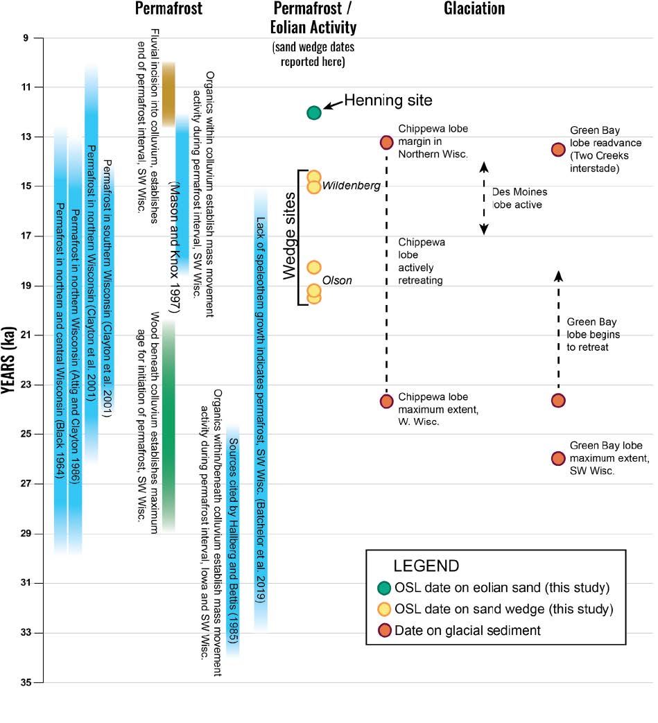
(Image Above: Glacial, permafrost, and aeolian activity in thousands of years before present (ka). Sand wedges and aeolian sand dated (with OSL) by the EARTH Systems Laboratory and collaborators are seen in yellow and green circles here. Created for a publication by EARTH Systems Lab faculty and collaborators. Schaetzl et al., 2021).
Human land use impacts on fluvial systems
- Project 4: Rivers in the upper Midwest, USA, have been dramatically altered and are still undergoing change due to the arrival of euro-american settlement and associated land use practices. This has primarily resulted from draining wetlands and the removal of native vegetation in favor of intensive agriculture land use practices. This activity has altered the hydrologic and sedimentologic regimes of these river systems in the historic record compared to natural background geomorphic processes. As such, it has dramatically altered how these rivers behave, how that behavior manifests itself in the changing form of the river’s floodplain and channel through time, and environmental problems associated with poor water quality. Two rivers have been the subject of intensive study by the EARTH Systems Laboratory and collaborators. These are the Minnesota and Whitewater Rivers of Minnesota.
- EARTH Systems Lab work on the Minnesota River was done in collaboration with Dr. Patrick Belmont at Utah State and with the MNSU Water Resources center. It was funded by the Lessard-Sams Outdoor Heritage Council and MN Department of Natural Resources ($424,928) and tied to invasive species prevention.
- Work on the Whitewater River is currently being funded by the LCCMR Environment and Natural Resources Trust Fund ($68,000) and is being led by the MNiMORPH research group. This work is continuing until 2024 and focuses on historic land use and planform dynamics change of the Whitewater River. This is coupled with ongoing work looking at post settlement alluvium aggradation in the Whitewater valley – led by Mr. Jimmy Wood (M.S. student at the University of Minnesota, MNiMORPH group) For more information, please inquire. Contact information below.
- If you are interested in this work, please contact phillip.larson@mnsu.edu
 |
 |
|---|---|
 |
 |
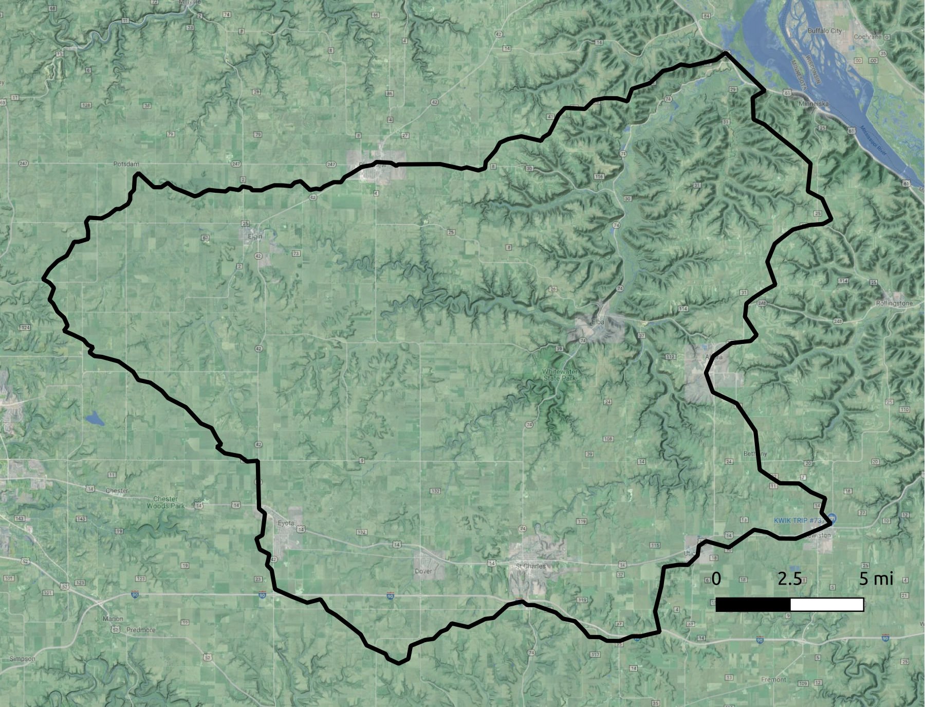
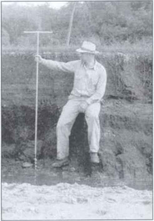
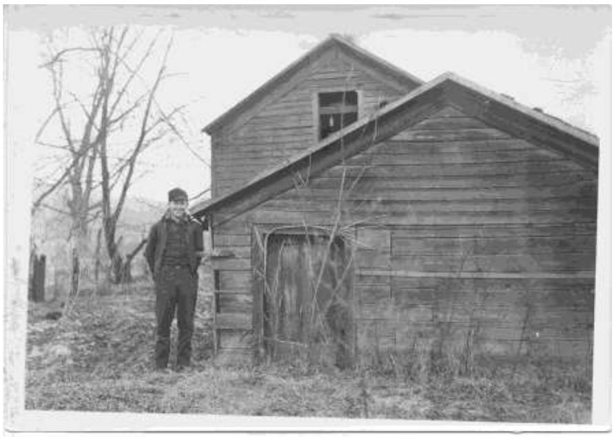
(Images Above: Top left image is the Whitewater River drainage basin in southeastern Minnesota. Top right image is from 1940. The man pictured is sitting on a bench of sediment that is pre-Euro American settlement. All the sediment above him as aggraded since ~1880. Bottom left image is of the Ira Card farm on Hwy 75 just east of the town of Beaver – note the sediment aggradation burying the farm. Bottom right image shows an example of Whitewater River change in the historic record.)
Drainage Integration, drainage basin reorganization, and basin landscape evolution
- Project 5: The EARTH Systems Laboratory is working to develop and further theory regarding the establishment of transverse drainages – drainages that cross topographic or structural barriers to flow (e.g. a mountain range). Transverse drainages often signal major drainage reorganization in the landscapes history and dramatically alter basin-scale geomorphic, hydrologic, and sedimentologic systems in the basins the river traverses post establishment of a transverse drainage. The development of geomorphic theory regarding fluvial system reorganization through drainage integration has been slow to progress since the abandonment of Davisian geomorphology in the mid-twentieth century. This is despite continued debate regarding the processes that result in rivers that cross topographic divides (transverse drainages) and the importance resultant integrated drainage networks have on economics, the establishment of modern water resources, and to understanding topics like the distribution of aquatic biology. Since at least the eighteenth century, geomorphic scholars such as J. Hutton, J. Playfair, J.W. Powell, G.K. Gilbert, C.E. Dutton, W.M. Davis, E. Blackwelder, T.M. Oberlander, and C.B Hunt described transverse drainages using a variety of terms like: water gaps, transverse valleys, transverse gorges, transverse river gorges, drainage anomalies, transverse trunk valleys and boxes. Collectively these scholars, along with contemporary modeling and research, have identified and demonstrated four basic processes by which drainage integration occurs and results in a transverse drainage. Antecedence occurs when a river maintains its position through sufficient erosive power during mountain building. Superimposition occurs when a river incises through erodible materials and becomes locked in place across a formerly buried bedrock high. Piracy occurs when a river establishes a new course down a steeper gradient path, resulting from the capture and rerouting of the original drainage. Overflow, or spillover, takes place when a closed basin fills up with sediment and water to breach the lowest sill to generate a new river path.
- Recent work on this has culminated in a special issue in the journal Geomorphology, led by the EARTH Systems Laboratory. See: https://www.sciencedirect.com/journal/geomorphology/special-issue/10769TKL6KQ
- Several publications have been produced on this topic:
- See: https://www.sciencedirect.com/science/article/abs/pii/S0169555X20304128
- See: https://www.sciencedirect.com/science/article/abs/pii/S0169555X20304852
- See: https://www.sciencedirect.com/science/article/abs/pii/S0169555X19305112
- Work tied to this also includes trying to understand piedmont landform development – i.e. pediments and alluvial fan dynamics.
-
- Work continues today focused on transverse drainage development and basin-scale geomorphic adjustment to drainage integration. If you are interested in this work, please contact larson@mnsu.edu
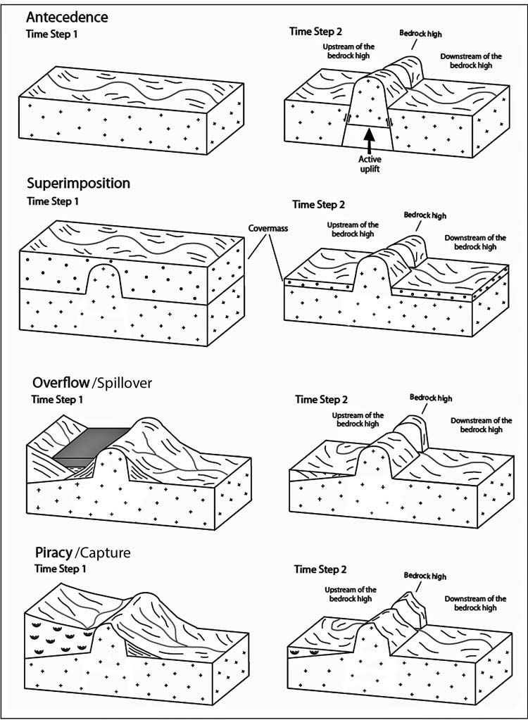
(Image Above: Transverse drainage mechanisms of antecedence, superimposition, overflow and piracy (capture). Created for a publication by EARTH Systems Lab faculty and collaborators. Larson et al., 2017)
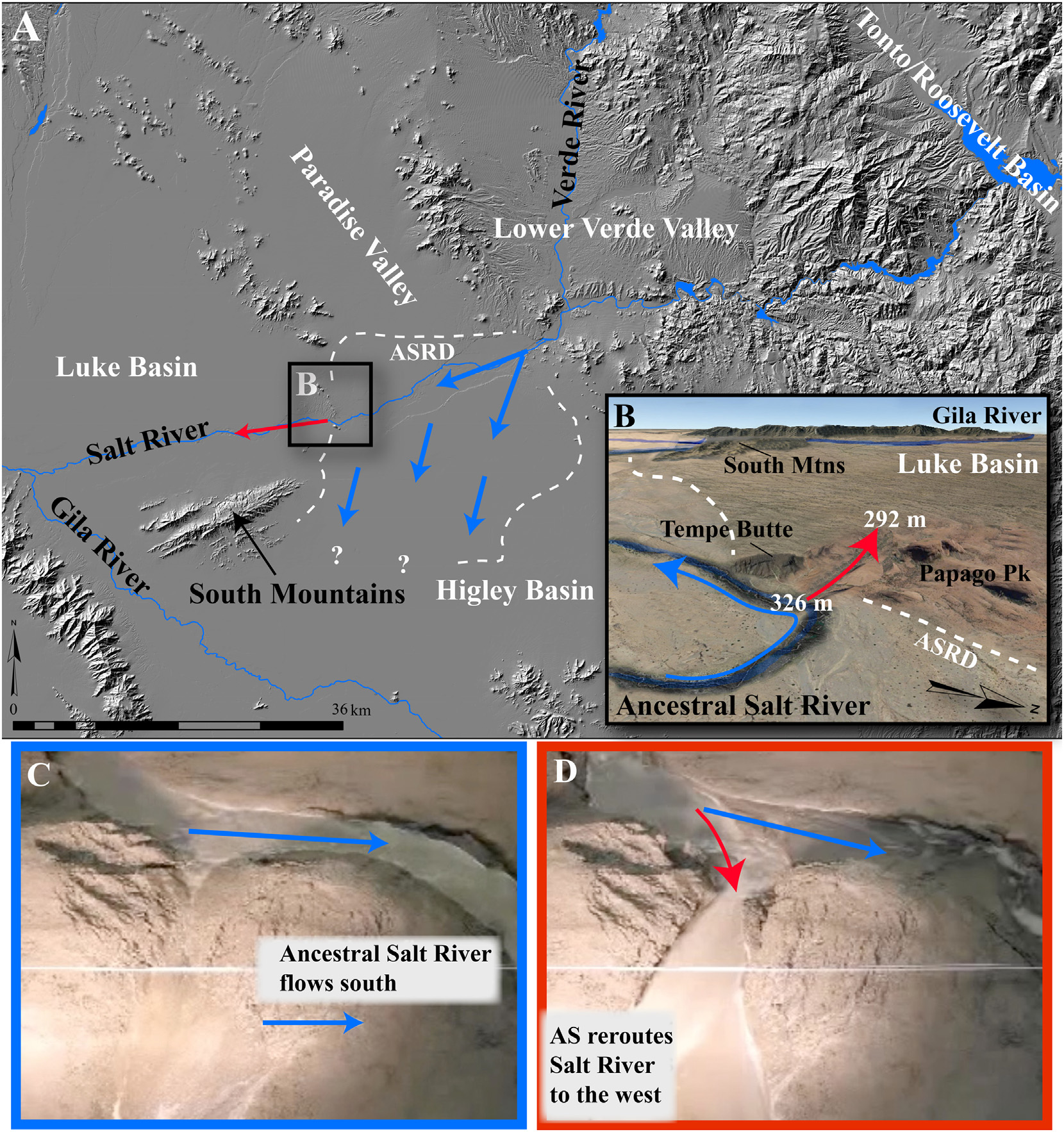
(Image Above: Aggradational Piracy or Aggradational Spillover event that resulted in the transverse drainage of the Salt River near Tempe, AZ, USA. For ~2million years, the ancestral Salt River aggraded within the Higley Basin, after a transverse drainage was established upstream that integrated the lower Verde Valley basin and the Tonto/Roosevelt Basin via Lake Overflow. It is hypothesized that aggradation reached a sill in the Higley Basin and spilled over near Papago Park into the Luke Basin. This Aggradational Spillover event redirected the Salt River's position from flowing south to its present, more westerly course – through the heart of metropolitan Phoenix, AZ, USA. Images C and D at the bottom show physical modeling experiments from Douglass and Schmeeckle (2007) demonstrating this exact process. Created for a publication by EARTH Systems Lab faculty and collaborators. Larson et al., 2020)